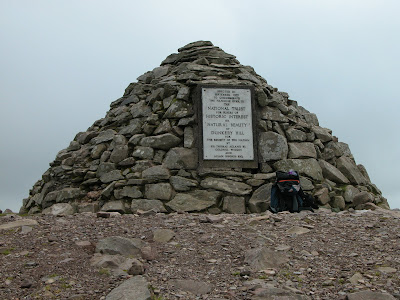
The weather prevented me having a real work out in Wales so I was anxious to get out. Today was ideal. But where to go ? I decided to explore an area which I imagine most people avoid due to it being very wet under foot. The area I chose was the triangle of land within Chetsford Bridge, Lucott Cross and Aldermans Barrow. Rather than just park up and jump over the hedge I decided to make a walk of it. I parked on Dunkery and walked up to the beacon,
 then down across to the hedgerow, which I followed to Porlock Post. I continued across Exford Common, across the road and out onto Almsworthy Common. I entered the triangle onto Hurdle Down and followed a path on the NW side of the marsh through shattered conifers to the stream junction. I looked left up the valley towards the road near Aldermans Barrow and remembered that I had once struggled down through those bogs many years ago. I decided to carry on down stream to the bridge. Still having plenty of time on my hands I continued down Chetsford Water. I soon became aware of stags bolving and herds of deer on each side of the valley.
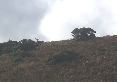
The above stag was on Great Hill on the north side, he did not appear to be very happy, he was shouting at the herd on the other side of the valley.
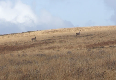
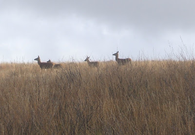 This concentration of deer was one of the largest I had seen. I followed the track as it climbed out of the valley disturbing the herd on the south side as I passed. I soon came out on the road down to Nutscale and turned right towards the road leading to Pool Bridge.
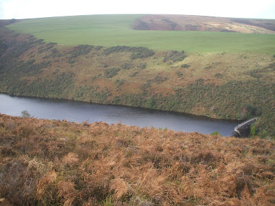


 Craig Cau.


 the very steep path to Burgundy Chapel, then along to Greenaleigh Farm. I set foot on the beach below Greenaleigh at about 1030am. The tide was still well in, to the west I could see that some climbing would be required at the west side of the beach. It looked deserted, I clambered over the first outcrop and came across three young men attempting the same route. They were wisely waiting for the tide to recede further, foolishly I continued until I was brought to a halt 12ft above the water where a very slimey groove blocked the route west. I was eventually joined by the trio on a very cramped narrow ledge. By now the beach was dry but the cliff below was undercut with no visible way down. Rather than return along the cliff we set about fixing a rope and lowered ourselves to the beach. Many times over the years I have climbed across the cliffs above the water only to find that it would have been faster and much easier to wait for the tide to ebb then just walk along the beach.
 The trio were obviously going to take their time and have a good look around so I left them to it. There were no other problems, I came out onto Selworthy Sands just as the sand was being uncovered. Peregrines with their rapid wing beat were racing across the cliffs and the weather was holding out.


 I climbed up via the Fisherman's rope into Coney Combe then on up to Selworthy Beacon before heading back across the hill, reaching the car just as the rain began to fall.
 We explored the caves down below the lookout and made our way out on to Selworthy Sands.
 The sands are really uneven at the moment with holes and pools running the length of the beach. Not much chance of light aircraft landing here for a while.
 The ascent up into East Combe has become difficult. A slide of wet earth has scoured the holds and buried the end of the fixed roped to the extent that there is no slack in it. It took about forty minutes to get everyone up into East Combe. Peregrines were seen flying across the cliffs above the sands. There were quite a number of people about, the car park was full with the overspill field in use. Yes, even I bought a ticket.
 For nearly thirty years climbers have pulled and stood on this block as it slowly eased its way to freedom. Fortunately, as far as is known it did not take anyone with it. Brandyman is located on the huge recess in the cliff overlooking
  On Wednesday I abseiled down the line of Brandyman to inspect the damage and try and find a way past it. I was stunned to find that the entire east side of the feature is in danger of sliding and falling from the cliff.
  On the 14th October 2007 it was reported that an overlap ( 5 ) had fallen. This did not affect the routes passing over it other than to increase the step up onto the slab above by about four inches. It was also noticed during October 2007 that the section ( 4 ) was dropping and the horizontal crack above was expanding in width. There has not been any noticeable change here.
 Unfortunately it seems that we have to let Brandyman go, as there is little point in climbing on rock that may not be there next week. Then again, it did take the hanging block twenty-nine years to fall.
 I drove down past Beggars Roost where the wind was moving the trees. Caught a glimpse of the sea down in Lynmouth, the white horses told me that this was not going to be easy. Normally I stay away from the
  Thankfully the goats had kept the path open as it skirted around the chasm between the Yellowstone Ridge and the Yellowstone Arete. I walked easily down the length of the Yellowstone Ridge
  to the end where fishermen have fixed bolts into the cliff. I believe they call this part of the descent ‘The Railings’. To the west (left) was the deep and narrow Mother Meldrums Gut, to the east, the East Inlet. It was my intention to descend down the west wall of the East Inlet and clean the holds for use later in the spring.
 I tied on and went out over the edge and soon discovered that even on a low spring tide the cliff was being hit by spray and the holds were covered in green slime. There was not much that I could do other than curse that I had allowed my impatience to draw me out on to the cliffs too early, again. I don’t think that I will ever learn. I climbed back up the rope and had my lunch. I gazed out across Woody Bay, I could see the swell striking the cliffs along the length of The Inner
 It is very steep just above the ruin, great care is required to avoid finding ones self on the beach much quicker than intended. I have been told that Rockford Cottage was intended to be the home of the butler to Ava Lovelace of early computer fame who resided above at
  Moving west the erosion of the cliffs continues until you past First Rocks. The wind was cold and from the west. I had done it yet again; I had come to the wrong place. The sun is not high enough yet to peek over the hill, the beach remained in shadow all day while over my shoulder I could see Hurlstone Point bathed in sunlight.
 I bashed on towards Culbone Rocks where the stream appeared to be in full flow. The thick rope a few yards to the west of the stream is still in place allowing the fit and strong to pull themselves up into the woods and on to Culbone. On arrival at The Ivystone I noticed a peregrine perched on the very top of the buttress seventy feet above the beach. The tides are quite high at the moment with low water being a long way out. Until Wednesday it should be possible to walk past the sixty-yard frontage of the buttress near or on low water. I played around for a while climbing across the lower part of
  I was shocked to find that the ridge that runs down on to the top of the buttress had shattered during the winter and the last few feet of the path was missing. Very carefully I crossed the debris on to the top of the buttress where the rock pinnacle is teetering above St Bueno’s slab.
 I would be surprised if it remains in place for much longer. The peregrine had flown leaving evidence of many pigeon meals on what is obviously its favourite spot. There are deer droppings on the buttress; they have been on the ridge and down the west side of the buttress to the beach. I climbed on the west side of the buttress on a route named Albatross until the tide receded allowing me to walk back to the east side where I had lunch at the foot of the slab out of the wind in the lee of the main buttress. I had a bag full of heavy climbing equipment. I did not feel like climbing up the ridge
 to the coast path so I retraced my steps back along the beach to Worthy Combe and the car.
  The weather did not look promising to begin with. Low cloud was settling on the Quantocks and North Hill, with a chilly northwest wind at 1000ft.
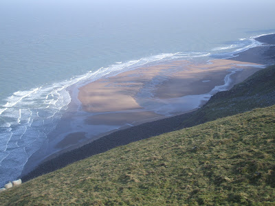 The sun eventually broke through allowing us to climb in shirtsleeves for most of the day. The air was really clear with views up to the Severn Bridge and way into The Brecon’s, where patches of snow could still be seen on the mountainside. Don’t know how much longer I can avoid paying the parking fee at Bossington, the climb back up to the car park on North Hill is taking a toll of a different kind.
 Didn’t know what to expect from the weather, the Brendons and the north side of Dunkery still had a fair bit of snow cover. A bad sign I am told if it lies about for too long.
 The Ravens are busy repairing their huge timber nests so maybe spring is not that far away. People are getting out again, there must have been well over twenty walking on Bossington Hill, plus a couple of Para gliders.
 It was possible to climb without the fingers freezing; I could not resist a quick traverse across the slab above
  Read somewhere yesterday that the most stolen book from UK bookshops is the A to Z of London. Can you believe that the second is OS maps, the main one being the Exmoor Explorer map?


 No chance, visibility across the top was down to less than 100 metres with a cutting east wind. The heather was covered in frost but this did not deter the mutt as he ran shovelling his nose through the heather looking for any poor bird to chase. We walked up from Dunkery Gate to the Beacon then across to Row Barrows. I did not have a compass, I used instinct to guide us across the two roads and out on to Almsworthy Common. Thankfully the dog returned each time he lost sight of me. We reached Alderman’s Barrow and turned back. It was far too cold to stop for a bite to eat, we had to keep moving.
  I would guess that the temperature would have been around minus 5 degrees. We crossed Codsend Moor keeping the field hedge in view for most of the way. The trees were covered in frost. Eventually we arrived back at Dunkery Gate. I was looking forward to sitting in the car and having a hot cup of coffee. Could I get the dog into the car? Could I heck. For twenty minutes or more I shouted commands at it from the list plus a few that I made up. It ran around in circles and jumped into the air as though it was on springs. I ran off through narrow gaps and tried to ambush it. I tried to bribe it with the official good boy rewards nothing worked. Eventually a woman with another dog casually walked up to him and caught hold of his collar. Daughter is collecting him on Sunday. I hope. We will all miss him especially the cat.
